On August 17, 1959 at 11:37 p.m. (MST) the ground began to shake roughly 10 miles to the northwest of West Yellowstone in Madison Canyon resulting in the strongest and deadliest earthquake to ever strike Montana — It caused a huge landslide that blocked the flow of the Madison river, caused 28 fatalities, and created ‘Quake Lake’.
See video:
The U.S. Weather Bureau reported at the time that the quake lasted 30–40 seconds. During the earthquake the surrounding landscape dropped as much as 20 feet and shock waves caused numerous seiches to surge across Hebgen Lake for 12 hours. Water pushed by the seiches poured over the dam which did not collapse. Several aftershocks ranging from 5.8 to 6.3 were reported after the quake.
The earthquake struck in Madison Canyon, an area to the west of Yellowstone National Park. Several nearby campgrounds were occupied by vacationing campers and tourists at the time.
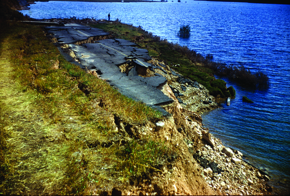
State Highway 287 slumped into Hebgen Lake — Although magnitude estimates for the 1959 earthquake vary (the United States Geological Survey recorded the quake at both 7.3 and 7.5, now calculated by the ISC as 7.2 Mw) the 1959 earthquake is comparable to the 1906 San Francisco earthquake as one of the strongest earthquakes in North America, behind the 1964 magnitude 9.2 Good Friday earthquake in Alaska.
The 1959 earthquake is also the most severe earthquake in the Rocky Mountain area of the United States along with the 6.9 magnitude earthquake which struck Idaho in 1983. The landslide caused by this quake was the largest since an earthquake in Wyoming in 1925 caused a landslide amounting to 50 million cubic yards of rock and debris that left 28 people dead.
The death toll from the quake was also the highest since the 1925 earthquake and most recent for the Northwestern United States since an earthquake in 1927 that left seven people dead. The 1959 earthquake was also the most damaging earthquake to occur in Montana since the 1935–36 earthquakes that left four people dead. The Hebgen Lake area also experienced earthquakes again in 1964, 1974, 1977 and 1985.
New geysers and cracks sprouted up in nearby Yellowstone National Park. Near Old Faithful, the earthquake damaged the Old Faithful Inn, forcing guests there to evacuate.
Landslides caused by the quake blocked a road between Mammoth and Old Faithful, damaging a bridge inside the park. There was one reported injury when a woman broke her wrist. The earthquake also created fault scarps as high as 20 feet, causing extensive damage to roads, homes, and buildings. In Belgrade, Montana the earthquake damaged measuring equipment placed in a 100-foot water well. The quake also knocked out telephone communications between Bozeman and Yellowstone, with the city of Bozeman itself suffering moderate quake damage to homes and buildings. Buildings at the Montana State University campus also sustained quake damage. In Butte, the quake caused a pendulum clock to stop at 12:42 a.m.(MST) and caused minor damage to homes.
Areas around Hebgen Lake were also affected as the quake caused parts of the lake to rise eight feet. Roads and highways running along the shores of the lake collapsed into the water. In Ennis, most residents were evacuated due to concern Hebgen Lake might flood the town. The evacuation was subsequently called off when it became known the landslide had blocked the river’s flow. In West Yellowstone, the earthquake damaged a courthouse and a railroad station.


")
