Operation Santa adopts an area of town every year and delivers gifts with Santa and his elves on Christmas Morning. They are led by the Great Falls Fire Dept and a horse drawn team.
Well this year our neighborhood was chosen by Operation Santa. When I first heard the procession I didn’t know what it was and I thought there might be a fire somewhere close by (had a house fire down the block a few months back).
When I stepped out the door to see what was going on, a bunch of folks, including Santa Claus came up the driveway wishing us a Merry Christmas and handing out gifts.
I’ve known for years that Great Falls is a great place to live and this business with regard to Operation Santa just makes this place all the more great. The kids jump up all bright-eyed and bushy-tailed to see what’s going on and are delighted by the procession with all of the bright Christmas colors, the horses, the fire truck, the music, and of course … the toys.
This program has been going on now for a few years and it appears to be quite a success. Volunteers are welcome and whatever support you might give to the organization will be gleefully accepted.
Operation Santa is a Nonprofit organization
You can get in touch:
Po Box 7435, Great Falls, Montana
(406) 799-8405
laura@iversconstruction.com
When I was a kid we would celebrate standard traditions and all gather ’round and open Christmas presents on Christmas Eve. Christmas day is when we would all gather ’round to eat.
What we did back in those days was different than what I had read in books at school. Those books talked about waking up on Christmas morning and rushing down to the Christmas tree to see what Santa had brought the night before (Christmas Eve).
As a kid, it didn’t bother me that we did things a little different though because getting toys before the other kids in town was sort of a big deal.
Christmas Eve or Christmas Day were fairly interchangeable during my single years as an adult, as again, tradition wasn’t really a thing.
Once our son was born I became suddenly more traditionally minded in that through the course of his young childhood I opted to rather have him wait until Christmas morning to discover his gifts under the tree. I remember him setting out milk, cookies, and carrots for Santa (carrots for Santa’s Reindeer) and then playing hell trying to get to sleep on the sofa in the living room while he waited for Santa.
This short family tradition (of 17 years) held up until this year. This year we opened presents after church on Christmas Eve day, in the afternoon. We also cooked the Christmas dinner on the same day. By doing it this way we reserved the entirety of the actual Christmas Day to do … well … nothing. Doing things this way may open up another yet to be discovered family tradition I think, because as I sit here this Christmas morning the wheels are turning.
I’ve always been an independent sort. Norman Rockwell I think would have been somewhat displeased with me in that even though I’ve looked at all of his traditional Christmas stuff, I just never really ever came around to that whole traditional American Christmas thing he kept going on about through his art. I know it all looks fine on paper, but the American spirit is somewhat much more diverse than all of that. Christmas is too great of a time to be trying to adhere to what someone else might think is appropriate or customary. American families create their own traditions every day all year long and that’s just fine with me. Freedom … it is what it is.
We may end up doing on Christmas the same things we do on Thanksgiving. On Thanksgiving my wife fixes a plate for our neighbors that may not have family or are too old to fix a full blown meal with all of the fixings. Just imagine if everyone thought of their neighbors in that regard. We could end hunger by next week at 2 o’clock if everyone took those who live close to them into consideration.
The so-called little tradition that we established with our son was broken this year and that isn’t necessarily a bad thing either. People are dynamic, fluid, and in constant change. Being stuck in just one spot as it might relate to tradition can be somewhat of a bore I think.
There’s a traditional saying that goes like this, “If you don’t behave, you’re going to get coal in your stocking”.
I’m sort of an odd duck I suppose (with regard to tradition) in that I’ve often found myself wondering why anyone getting coal in their stocking was such a bad thing. Having heat in the middle of winter sounds like a dandy deal to me.
Life is such that families are going to arrange their own traditions accordingly. Some families will make arrangements with regard to their work, extended family, distance apart, and so on and so forth. The traditional Christmas is set more as a guideline than anything else. We’ve got the very basic concepts of Christmas established and that frees us up to make our own Christmas traditions.
In closing I’d like to add a quote from a friend in Missoula who said —
“If you see someone at the store today struggling somehow just help them out. Don’t think about it. Just do it. They will really appreciate it.”
I think that quote says it all and captures quite nicely what Christmas is about. We should all consider making what he said not just a Christmas tradition, but rather a tradition to be practiced throughout the entire year.
I hope that this Christmas season finds you and yours well in all of what you do.
Stuck for something to do? Well this just might be something to look into if you’re interested.
Enjoy the beautiful wilds of Montana by becoming a Crew Leader or an Intern with the Wilderness Foundation.
Applications are now open for the 2024 field season.
Crew Leader positions were posted December 19th, 2023 and will be accepted until all position are filled.
Internship application acceptance began on December 20th, 2023 and are due by February 1st, 2024 (late applications will not be considered).
Spend the summer in the 1.6-million-acre Bob Marshall Wilderness Complex, giving back to trails and helping more folks connect with this magnificent landscape.
I think ancient temples are cool. Anyone that knows me also knows that I’m just a bit of a history buff. I’ll set about to reading and sometimes I’ll forget to stop.
This morning I was looking at some past history and happened across the old stone works from centuries back in the day and I thought to share.
Roughly 700 to 2,000 years ago, ancient cultures around the globe erected some of the most amazing structures on the the planet.
Using incredible knowledge of mathematics, astronomy, engineering, and architecture, ancient people created truly wondrous monuments to stand the test of time.
Some of these structures are engulfed in mystery, as they defy everything we have been taught about ancient cultures.
From laser-like cuts to supermassive blocks of stone weighing up to one hundred tons, these incredible ancient structures prove that our ancestors were far more advanced than what we are crediting them for. I mean these guys literally took the time to focus and think things through.
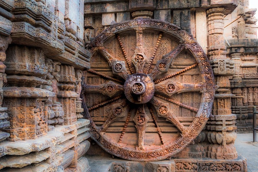
The Konark Sun Temple. This ancient temple located in Orissa, India was built by King Narasimhadeva I of Eastern Ganga Dynasty in 1255 AD.
This ancient temple located in Orissa, India was built by King Narasimhadeva I of Eastern Ganga Dynasty in 1255 AD
This temple beyond stunning as it features a number of intricate design details that will make your jaw drop.
The temple itself was shaped like a gigantic chariot, but its breathtaking design elements are the smaller ones, like the elaborately carved stone wheels, pillars, and walls. A major part of the structure is now in ruins.
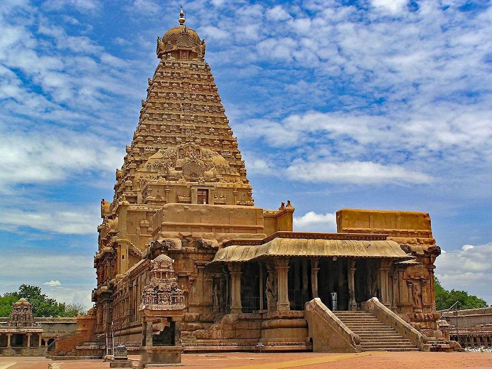
Brihadeeswarar Temple dedicated to Lord Shiva and commissioned by Raja Raja Chola I
Another temple, perhaps equally stunning is the so-called Brihadeeswarar Temple dedicated to Lord Shiva and commissioned by Raja Raja Chola I. The temple was completed in 1010 AD. This temple is located in the Indian state of Tamil Nadu. One of its most prominent features is the massive 40-meter-high Vimana—one of the largest in the world. The entire temple was built out of granite, and scholars have calculated that the ancients used more than 130,000 tons in its construction.
Prambanan temple compound, home to 240 rocket-like structures
The Prambanan temple compound, home to 240 rocket-like structures. This ancient temple compound is believed to have been erected during the 9th century under the Sanjaya dynasty of the first Kingdom of Mataram in the Central Java region. Prambanan is considered the most significant Hindu temple site in Indonesia, and one of the biggest in Southeast Asia. The stunning rocket-like structures are characterized by its tall and pointed architecture style, which, according to historians, are typical of Hindu architecture and by a towering 47-meter-high central building inside a large complex of individual temples.
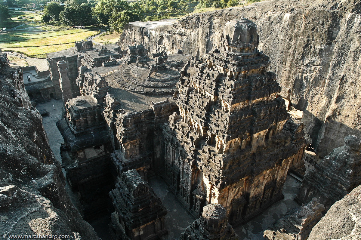
The Kailasanatha temple (Cave 16) is one of the 34 cave temples and monasteries are known collectively as the Ellora Caves
Another really cool ancient temple is located in Ellora, Maharashtra, India. This ancient wonder of the world is considered the largest rock-cut temple on the surface of the planet.
The Kailasanatha temple (Cave 16) is one of the 34 cave temples and monasteries are known collectively as the Ellora Caves. Its construction is generally attributed to the 8th-century Rashtrakuta king Krishna I in 756-773 AD.
From India, I went over and looked at Egypt.
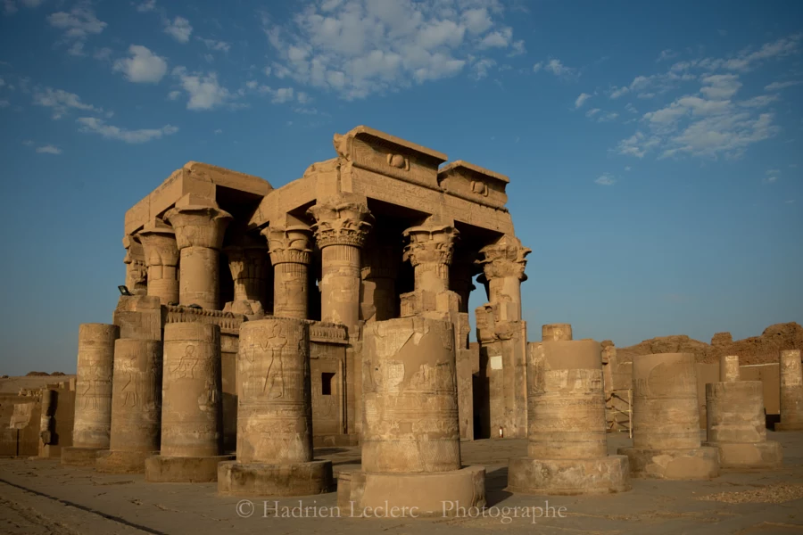
There, in the land of the Pharaohs, we come across the Temple of Dendera, an ancient monument built to honor the Goddess Hathor.
The Temple of Dendera features a mysterious relief that some authors claim depicts a massive lightbulb used by the ancients Egyptians
Curiously, this temple, located a mere 2.5 km southeast of Dendera, is one of the best preserved Egyptian complexes, especially its central temple, thanks to which it remained buried by sand and mud until it was unearthed by Auguste Mariette in the middle of the 19th century.
The Temple of Dendera features a mysterious relief that some authors claim depicts a massive lightbulb used by the ancients Egyptians, suggesting that thousands of years ago, the ancient Egyptians had access to advanced technologies like electricity.
This ancient temple is one of the most curious temples in Egypt mostly because of the enigmatic ‘bent’ stones that lie inside the temple. It features supermassive blocks of stones, some exceeding 150 tons in weight, and design elements that eerily resemble elements found halfway around the world, in Peru.
Giant Pyramid-temple of Borobudur
The Giant Pyramid-temple of Borobudur. This magnificent ancient structure is considered the largest Pyramid-shaped Buddhist monument in the world, but it is also one of the most intricately designed structures on the surface of the planet. mainstream scholars have no idea who erected it, what its original purpose was, nor how on earth it was built.
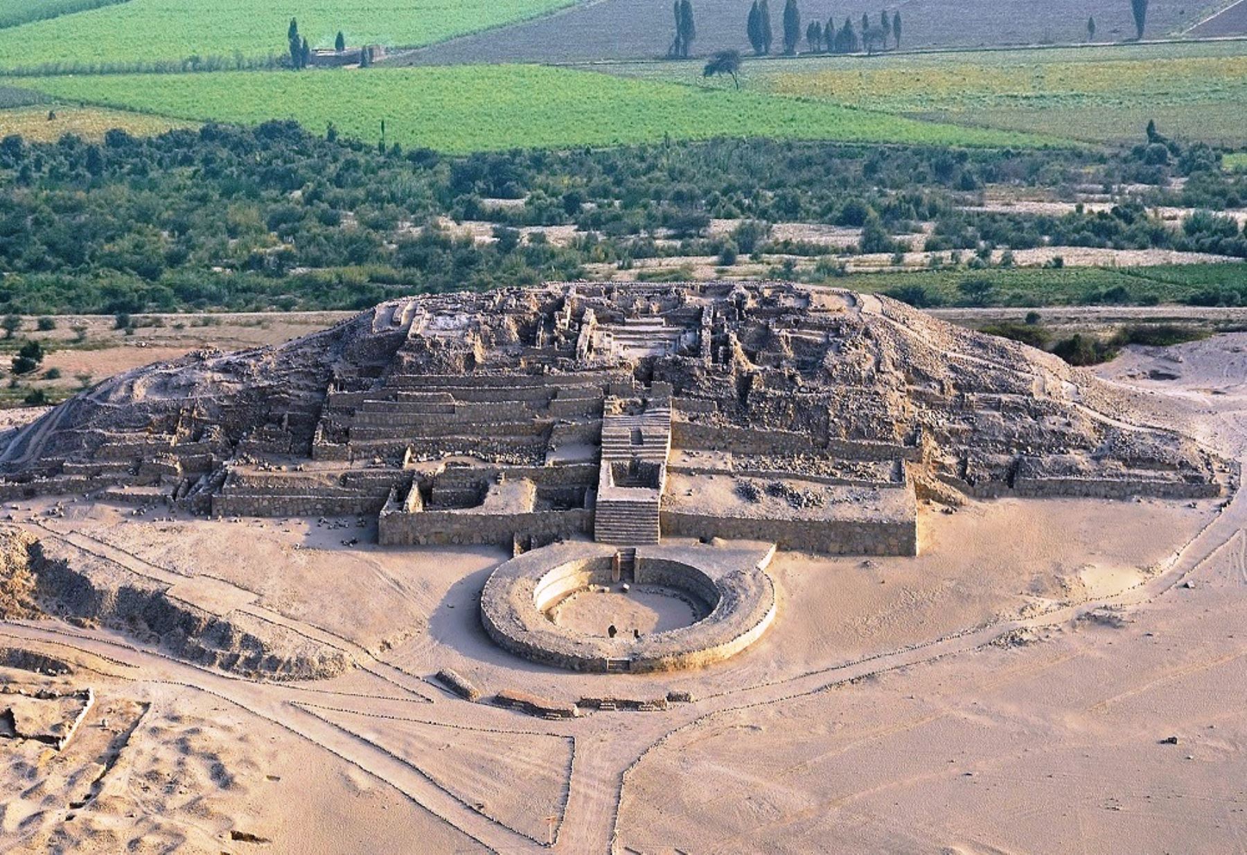
Caral archaeological complex, in Peru. Almost 5,000 years old, it was built by one of the oldest cultures in the world
Few people are aware of the fact that hidden deep inside the desert region in Peru, more than 5,000 years ago, an ancient civilization erected magnificent temples and pyramids.
The Pyramids and temples of Peru are believed to predate the Pyramids of the Giza plateau by at least 500 years and were erected by the Caral people.
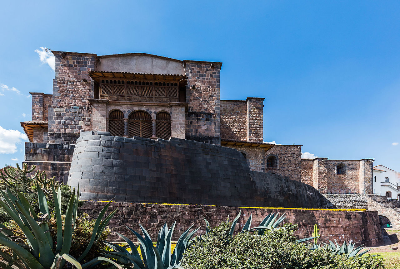
The Temple of the Sun (Coricancha) is part of a beautiful complex composed of several temples.
Here’s the Temple of the Sun or (Coricancha, Koricancha, Qoricancha or Qorikancha), the main Inca Sanctuary. Its internal walls, embedded and molded with millimetric precision, surprise even more when it is known that during the Inca Empire they were not ‘naked’, but that all the walls of the temple, according to Garcilaso de la Vega who wrote about Coricancha in the late sixteenth century, “were covered from top to bottom with massive gold planks.”
The Temples of the Sun (Coricancha) is part of a beautiful complex composed of several temples.
And last but not least, one of the many ancient temples in Cambodia.
There, in the city of Angkor Thom lie the ruins of the temple complex of 200-smiling-faces: The Bayon Temple.
Four-faced towers in Prasat Bayon, Angkor Thom, Angkor, UNESCO World Heritage Site, Siem Reap,… by robertharding on 500px.com
This ancient temple was built at the end of the 12th century, it was completed during the reign of Jayavarman VII. It was created in Buddhist style. The temple is oriented towards the east, and so its buildings are set back to the west inside enclosures elongated along the east-west axis. It is best known for its 54 towers and more than two hundred Buddha faces which give off a sensation as if they were staring at you with a relaxed, calm, and beatific look.
Originally published by Steve Gillman — December 07, 2023
From ancient Egypt to medieval England, cultivating one or more crops in the same field was common practice among many farmers for thousands of years. However, in the last century, food producers largely stopped ‘intercropping’ and moved towards an industrial type of agriculture – a shift that contributed to 34% of the world’s farmland being degraded today.
“Interest is growing in intercropping again because farmers increasingly understand it improves their soil health,” said Jerry Allford, an organic farmer and advisor from the Soil Association, a UK charity promoting sustainable agriculture. Jerry thinks this renewed focus can “open up a whole new way of farming” because it can bridge profitability with regenerative agriculture practices.
“In the case of growing a legume and cereal together, we know there is nutrient transfer between the two crops,” he said, adding that this reduces the need for synthetic fertilizers and its associated costs. Other potential benefits include reduced weeds, pests, and diseases as well as higher resistance to extreme weather from climate change – all of which can improve farmers’ bottom line.
To understand and amplify the potential of intercropping, Jerry is running a range of trials where farmers grow a mix of crops on the same stretch of land. This is part of an EU project called LEGUMINOSE which is researching the benefits of intercropping in eight European countries, as well as in Egypt and Pakistan. In total, there will be 180 ‘living labs’ where farmers in monoculture systems introduce a strip of intercropped cereals and legumes, such as wheat and peas or barley and broad beans.
Each living lab will be tailored to its region with the farmer choosing the techniques and crops most relevant to their area, such as drilling depth, seed mix and planting methods. The idea is that this will enable food producers to produce more practical results, something which LEGUMINOSE wants to use to attract others to intercropping.
One of the UK’s living labs recently finished and Jerry says it has already provided an insight into intercropping’s promise. The test farm planted wheat and beans, reporting a 27% increase in the intercropped plot compared to the monoculture strips on the same farm. Less weeds were also reported while a preliminary analysis of the soil showed less plant disease present between the two, meaning less need to buy and use agricultural chemicals.
The economic potential of intercropping does not stop there either. Farmers can choose to grow a secondary crop for the market, such as a legume for human and animal consumption, or a plant that can enhance the quality of a primary crop.
“We’re also finding that intercropped wheat is meeting UK milling specifications easier, so it could produce a premium price for the farmer,” Jerry said, adding that he hopes this drives an uptake of intercropping and the practice becomes mainstream in the agriculture sector.
Models for scale
In Europe, only 2% of farmers currently use a legume-cereal intercrop. Shamina Imran Pathan, LEGUMINOSE’s project coordinator, says it will not be easy to make the practice go mainstream, but providing farmers with the right information and tools can help them switch quicker from a monocultural farming system to a more regenerative one.
“Many farmers still don’t know what intercropping is,” Pathan points out. “That’s why we need to involve more and more farmers to increase their knowledge about mixing crops together.”
The living labs are designed to galvanize discussions among farmers and boost uptake that way, but LEGUMINOSE will also reinforce this knowledge through seven additional research fields that explore the benefits of intercropping in precise detail. Academics from several European universities will collect soil samples from farms and conduct a range of physical, chemical and biological analyses to explore the benefits of intercropping on a range of aspect, such as those around soil health, pesticide reduction and crop quality.
Early results have also shown promise here too with one trial finding that wheat intercropped with clover completely removed the presence of a parasitic weed called dodder – a benefit that could reduce the need to use herbicide and help farmers’ cut down on their input costs.
Pathan explains this data will be combined with the regional information from the living labs to create forecasting models based on artificial intelligence. This will be made available to farmers as a web-based tool in the coming years that they can use to select the optimal intercrop combinations for their specific situation.
“Farmers can use this to input criteria like their soil type and climate, and the tool will then tell them what combination of crops could work for them,” Pathan said.
sourced –
This article was originally published by RealClearPolitics and made available via RealClearWire.

 When I stepped out the door to see what was going on, a bunch of folks, including Santa Claus came up the driveway wishing us a Merry Christmas and handing out gifts.